
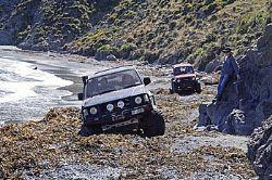
In Wellington we are very lucky to be able to escape to the south coast around from Owhiro Bay, the area known locally as Red Rocks. As well as being popular with the local 4WDers the area is well-liked by surfcasters, divers, walkers, cyclists, trail-bikers and quad riders. It is also home to a number of nesting birds, some roaming cattle and two seal colonies, not to mention the families living in baches in some of the bays. With all these different demands on the area it is essential that everyone is considerate of other users. For 4WDers this means keeping the speed down, sticking to the track and not leaving rubbish lying around. As you may have gathered from some of my earlier articles, this is one of my favourite areas. It offers everything from beautiful, peaceful, sheltered picnics on the beach to a view of storm-tossed seas with spray whipping over the beach, enjoyed from the shelter of your vehicle. It is also somewhere I always try to take any overseas visitors as it is so different from what they will usually have seen. The trip starts from the road end at the site of the old Owhiro Bay quarry through a gate that is locked on Sundays to give walkers some peace from 4WD traffic, but unfortunately not trail bikes. Back in the 1850s, this area was known as Ohariu, and was the site of a Maori pa, one of four around the coast from here, all of which were being progressively abandoned as the inhabitants were attracted to the developing settlement of Wellington and the colonial way of life. In the early 1920s a quarry was established, which operated until it was bought by the local council and closed down in 2000. The abandoned quarry became quite an eyesore and the council has put a lot of effort into stabilising and re-contouring the site. Work is now under way on the first two bays past the gate to get vegetation to grow on the bare, inhospitable banks both for beautification and to prevent further erosion. The plea is therefore to keep off these banks. 4WDers seem to be quite good in this respect although the “Please Keep Off” signs seem to be ignored by many of the trail bikers who find it a great area to practice their jumps. From the gate an unsealed reasonably formed but potholed and bumpy road suitable for any reasonably capable SUV drops through Hape Stream then winds its way around the coast past a number of baches for about 2 km before reaching the actual Red Rocks area. Geologically the red rocks come from an old sea bed and consist of a combination of pillow lava from an undersea volcano, volcanic sediments and red chert squeezed between near vertical beds of Wellington greywacke that run back into the hills. It is the iron ore in the rocks that give it the red colour. There are a number of Maori legends about these red rocks, the most widely known being that it was the blood from Maui’s nose when he used his own blood to bait his hook before catching the North Island. Other legends say that it was the blood of Kupe when he cut his hand on a paua shell or the blood of his daughters shed in mourning when they thought their father was dead. The road continues at a similar standard for another km, past some more baches and fording another small stream before reaching Sinclair Heads and the first seal colony. This stream was the site of another Maori pa that had been almost totally abandoned by the 1850s. There is now no sight of the pa, but there are a number of baches in the area, some of which were built in the early 1900s. These are largely unchanged and recognised as historically significant buildings. They are privately owned and used as weekend or holiday retreats. In non-technical terms the Sinclair Heads seal colony seems to be the overflow sleep-out for the main colony further round at Tongue Point as, while there are seals at Tongue Point all year round, they only occupy Sinclair Head in winter. Both colonies are haul-out rest areas for males not involved in breeding, although I have occasionally seen pups here. The Conservation Department guidelines are to keep well back from the seals – if they react to your presence you are too close. Apart from the fact that they give a whole new meaning to the terms “bad breath” and “body odour,” they can be aggressive if you get too close. Take great care if climbing on the rocks as boulder-hopping onto a seal is not recommended! To get past Sinclair Heads the road goes up and over a very rough and technically quite challenging cutting through the rocks, called Devil’s Gate – there was a gate here once. Most drivers take note of the sign warning that real 4WD skills are needed from here on, and treat this as the end of the road, walking over to see the seal colony. Likewise most walkers have the seal colony as their destination. If I am looking for a chance to get away from Wellington for a lunch break, rather than doing a more serious trip, I will often just park up here to enjoy the scenery. It is also interesting to watch the different approaches people take to conquer (or not) Devil’s Gate. I have seen many people come to a grinding halt by taking the wrong line or going too slowly, and have seen and heard those who rely on enthusiasm doing some very expensive-sounding banging and crashing on their way over. There have also been a few cases of people running down the bank onto the beach when reversing from a failed attempt. It is, however, quite possible to get over Devil’s Gate with no drama if you take the right line and use a SMALL amount of momentum. If in doubt it is well worth spending some time watching others going over to learn what works and what doesn’t. When attempting the climb please don’t wheel-spin and dig the holes out even deeper as many of the local bach owners need to get through here to get to their homes. Once over Devil’s Gate you start getting views out to the west, with the South Island clearly visible on a fine day. For me the views and the interesting part of the trip start here. It is a wild area that can be spectacular in any weather. The track is now a lot tighter and rockier, in some places running through the soft sand around the top of the picturesque crescent bays. On a good day these can be fantastic picnic and fishing spots and I always debate whether to do the 4WD thing and keep going as far as I can or stop and enjoy being there – so I usually do both. There is a temptation to drop down into these bays but apart from one or two exceptions where the track obviously drops onto the beach, it is better to “tread lightly” and stick to the main track as there may be birds nesting in the kelp and driftwood, or you may end up driving through someone’s surfcasting fishing rod. On the landward side of the track you will see a number of roads and some challenging tracks running up the hillside or over sand dunes. Most of these have signage saying “Private property, please keep off”, and all are no go areas, both because the landowners don’t want people on them and because of the damage that can be done to the vegetation and bird life. A lot of regular visitors and locals will photograph vehicles playing on these tracks and report them to the council. Action is taken so be warned. The track continues around a number of bays and through a few small creeks past the sewerage outlet at Karori Stream. Although this may not be an area where you want to linger the soft sand in the nearby bays and the way the track is constantly shifting means this is the area where you are most likely to get stuck, especially after a storm. If you are in doubt about the route, wait for someone else to go through, then you can either follow them or help recover them. If you are going this far you should be carrying adequate recovery gear, especially since many people don’t. It is not at all uncommon to find very stuck vehicles in this area, especially on the steeply sloping beaches. While this is not a big drama with a group of well equipped vehicles, I have seen many recoveries attempted using a length of rope from a cray pot, connected to an old strop by a shackle, with neither vehicle having a rated recovery hook. Although it is a temptation to just leave them to it, I will always help out if things are looking dangerous since I don’t want to have to live with coming back to find someone has been killed by flying bits of broken recovery gear. Heading on, the next main attractions are the Karori lighthouse and the main seal colony at Tongue Point. There are a few narrow rocky areas on this part of the track, but the main hazard can be the seals themselves when they decide to sleep in the middle of the track. There are at least a few seals present all year round at Tongue Point, making this the final destination for the local Seal Coast Safari tour. You can often see their distinctively sign-written Toyota Landcruiser at Tongue Point, with the tourists enjoying watching the seals while having a hot drink and muffin. Most tourists I have spoken to have nothing but praise for the experience. The Karori lighthouse on an off-shore rock out from Tongue Point was built in 1915 and operated until 1996 when it was replaced by a new beacon on the hills above Tongue Point. To be fair to the designers, although from the side the lighthouse appears to be our version of the Leaning Tower of Pisa, the horizontal surfaces are still horizontal so the unequally sloping sides were presumably a deliberate design feature. Beyond Tongue Point the track is somewhat easier for a while, with some nice grassy areas for a picnic. This is about as far as I normally go. If you keep on a bit further you reach a very difficult beach known as Cave Bay. The track through here can be very soft and covered with kelp. Also, because the tide comes right up to the cliffs it can only be attempted at low tide. Although I have taken the Prado through here I would only attempt this in a party with a few powerful, light vehicles able to recover a stuck vehicle before the tide comes in. The other thing to remember is that this is a dead-end track so you still need to return before the tide gets too high. The final few km past Cave Bay are quite easy in comparison, with the track ending at the Terewhiti Station gate just before Oteranga Bay. Oteranga Bay used to be the site of another of the Maori pas, but its current claim to fame is that it is where the Cook Strait cable comes ashore and heads for the Haywoods substation. While the return trip is a re-run of the route in, you get the views in the opposite direction. There is also an interesting section just past the gate after Tongue Point where the track climbs slightly up the beach through some very soft sand. This is much more difficult heading out than heading in and creates many interesting situations where people get stuck coming out, someone drives in to help them, then people get stuck again trying to get past each other. The final bit of excitement on the way out is the return trip over Devil’s Gate. Getting to the top is easy but coming back down involves some fairly severe angles and sudden drops. People usually keep too far to the left as they come down to avoid the drop-off on the right, then catch the back bumper on the rocks as they drop into one of the holes. Once again the right line is everything – plan your route then take it VERY slowly. Overall one of the main things I like about this area is that it is available to anyone with a 4WD, and with some experience in off-road driving everywhere up to Cave Bay is usually readily accessible. It is a beautiful area to visit and enjoy, but it should treated with care and respect.
Adventures on Wellington's South Coast
Monday, 26 May 2008