One of the many bucket list trips for me has been to explore the Southland / Milford area. This included Walter Peak Station, Mavora Lakes, Milford Sound, Manapouri, Borland Road, Lake Monowai and, if possible, out to Lake Hauroko. While these are all public roads and do not necessarily require a 4WD, there is a lot of gravel and so it is easier in a 4WD especially when the intention is to camp out in spots where the hordes of tourists in slider vans and camper vans are not staying.
The plan then was to drive from Geraldine to Kingston at the south end of Lake Wakatipu the first day and set up camp there – about five hours and 380km so a relatively easy day. The second day was to drive out to Walter Peak Station for lunch and be back at Mavora Lakes by mid-afternoon to camp overnight by the lake.
The third day was to drive out to Te Anau, refuel there to ensure a full tank, then head out to Milford Sound and spend some time there enjoying the vista down the sound to Mitre Peak, before returning to Te Anau and possibly camping at the DOC Henry Creek campsite.
The fourth day was to go to Manapouri to look at the ferry terminal for the cruises to Doubtful Sound, travel on to Borland Road and go out to South Arm of Lake Manapouri, check out Lake Monowai and the power station on the way back, then out to Lake Hauroko (the deepest lake in NZ).
We would then camp at Monowai (if it looked good) on the way back to Te Anau or at Te Anau itself before driving back to Geraldine on day five – about 1700km in five relatively easy stages. For guidance with some of this trip I was able to reference Mark Wilson’s book 4WD South (Mt Nicholas Road, Mavora Lakes, Borland Road), plus using Google Maps to get milage and rough times to plan the trip.
The first attempt was called off when Covid hit and we all had to camp at home. The second attempt was called off when family members caught Covid and as we had been visiting them days before they tested positive, we decided it was better to can the trip than find we had also caught it and had to isolate in a campground somewhere. As we had sold our tent and camping gear in the meantime (pulling tent pegs out was hurting my back and the standard stretchers were not wide enough for 70+ year olds who cannot bend in the middle like they used to), attempt three was to be based out of a motel in Te Anau for four nights. I discovered that at 1 October most motels and hotels in that area switch to their high season rates until 30th April. This meant a room went from $240 per night to $480 per night. So, I booked the motel for the last week of September. I then found Borland Road is closed until 30 October each year so that was a no-go. High winds and heavy rain hit the Te Anau area that week, Milford Road was closing and opening intermittently through that period with rock and snow avalanche warnings, the road out to Walter Peak has two fords that are weather dependant, so after some muttering, I cancelled attempt three. As I did not want to pay tourist rates for a motel, I researched options for a new tent and bigger stretchers and came up with a solution from Adventure Kings. This consisted of a 3m x 3m gazebo into which you hang a tent utilising the gazebo frame, 210cm x 90cm stretchers with 30mm mattresses, and XL 210cm x 90cm sleeping bags with waterproof outers and good down to -3c. Best feature was it needed no tent pegs at all, unless the wind got up whereby you could put on the optional guy ropes. After a sales job on the Minister of Finance, the gear was purchased and attempt four was set up for the next break in the weather. There looked to be a four to five day window of fine/cloudy weather in the last week of November so I put the platform, Waeco fridge and secondary batteries (one for fridge and one for camp lights) into the back seat area of the BT-50 and packed all the camping gear in the tray ready to go on attempt four of the Te Anau trip.
Setting off from Geraldine just after 8:30am, and being patient with the many rental cars, SUVs and camper vans (some being driven erratically at times), we got to Omarama in time for a coffee break at 11:00am at the Wrinkly Ram. While there we overheard the conversation at the next table where four guys were discussing what their options were because the Lindis Pass was closed by a fatal accident and would be shut for a least six hours. Like many others, we opted to go to Duntroon and take the Danseys Pass Road through to Naseby, Alexandra and then back on track at Cromwell. Unfortunately, many others were coming the other way as well, many of whom were in cars, not used to driving on gravel and certainly not keeping left around the corners. After several near misses and some very tight squeezes to get past on the one lane road, we made it through with no damage. This added 145km and 3.5 hours to our trip though. In hindsight, it would have been quicker, but further, to stay on the tarseal and go right down to Oamaru, Palmerston and up the Pig Route to Ranfurly. When we got to Cromwell, the Lindis road was still closed. When we got to Kingston, the camp was full, and the wind was blowing down the lake, so we continued to the Mossburn campsite where we found plenty of room out the back in the non-powered sites. A long day of 9.5 hours driving so glad to pitch tent, get the dinner on and crack a bevvy from the Waeco.
Unfortunately, Mossburn campsite had a pair of peacocks which roamed free through the camp and screamed all night resulting in very little sleep. It was a relief to pack up and get on the road.
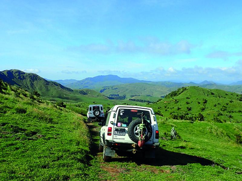
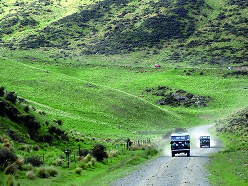
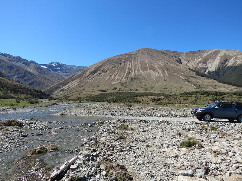
From Mossburn we headed up SH94, turned right into Centre Hill Road. After only 3km we got on to the gravel which was in good condition but dry and dusty. At 16km it was right on to Mavora Lakes Road. At 34km we carried on ahead on to Mount Nicholas Road (left was to the Mavora Lakes). At 36km we stopped at the Oreti River bridge for smoko. This has a shelter for the shuttle pickup of the Around the Mountain Cycle trail, a great long drop dunny and a picnic table. The road through this valley was relatively flat, in good condition and very dry and dusty. At 41km we came to the Ford at Gorge Burn which was ankle deep. Along this section there were big, eroded hill faces indicating that there would be a lot of water run-off when raining. At 47km there is a bridge over Bush Creek with a ford upstream if you want to get the truck wet. At 53km the culvert over White Burn showed signs of recent flooding with erosion and wood debris on the up side. Whilst the road was relatively flat up to this point, at 55km we came to the steep hill up from the Von River South Branch gorge. Great to look down but I would think the cyclists on the Around the Mountain trail coming from Walter Peak would be gutted by the time they got to the top. We had seen signs that the road had been recently graded and at the bottom of this hill we met the grader so it was very recent.
At 64km was the Old Nicholas homestead which we stopped to look around. On the other side of the road here was another shuttle pickup shelter and long drop dunny. Around the corner was the ford at Station Burn which again was ankle deep. Continuing, there were views of the Von River gorge on the left until we came to the first of the views of Lake Wakatipu at about the 70km mark. We carried on ahead at the turnoff to Mt Nicholas Station as we were going to Walter Peak Station. From the road you could look down to the Mt Nicholas Station woolshed by the shore of Lake Wakatipu, across to the road going up the far side of the lake to Glenorchy and to the top end of the lake at Glenorchy. Stunning mountain scenery around a blue lake. As we got to Walter Peak Station (about 84km from SH94 turnoff) we could see the Earnslaw had just left Queenstown and the RealNZ boat was arriving at the jetty bringing tourists from Queenstown across the lake to have lunch, sheep handling demonstrations and horse riding. We waited to see the Earnslaw tie up to the jetty but decided to leave before the 200 or so tourists came ashore – there was already about that many milling around the homestead from the RealNZ boat, taking selfies with random things in the background. Lunch for us was off the tailgate beside the road overlooking the Von River on the way back to Mavora Lakes.
This is a great road with stunning scenery along the whole length. On a fine day it is brilliant, not so sure what it would be like in the rain. We met several groups of cyclists who had been dropped off earlier in the day at Walter Peak, making sure we slowed down well before them so that they had a break in the dust after we passed them. The fords posed no problems for us in the BT-50 but could have stopped some cars. Would be different after rain. As a day trip, I would thoroughly recommend the trip out to Walter Peak Station.