The extremes – in terms of altitude, topography and climate – in Kyrgyzstan are incredible. All the better for a 4WD adventure, reckons Kiwi Overlander Aaron Rich.
From afar it could be easy to assume that the various ‘… ’stan’ countries of Central Asia are all much the same.
But – believe me – they are not.
Okay, at one time they were all part of the former Soviet Union, yet the incredibly rich human history to this region dates back so much further than that. And geographically, scenically and culturally, there exists striking differences between these countries.
Kyrgyzstan is the second ‘stan’ we explored, and as shown with this article its landscapes are wildly different from the unique desert settings shown with my previous article from Kazakhstan.
In fact, nearly 90 percent of incredibly mountainous Kyrgyzstan is situated above 1,500 metres elevation – most of it much higher, right up to the country’s highest peak at 7,439 metres!
The drastically varying altitudes we explored at throughout Kyrgyzstan caused us to experience wildly different climates, seemingly as if from totally different seasons through the year. Around 3,500 metres we camped in freezing temperatures and often snow. Yet this was followed by a return to T-shirts and shorts in the 30-degree Celsius temperatures still prevailing in early October in cities like Osh (963 metres) and Jalabad (575 metres).
Because there’s simply no way I can cover a whole month of exploring this fascinating country in a single article, here I will focus on our journey to an incredible place known as Kel Suu, which is not easily accessed. I’ve provided a broader set of photos though, in order to show you more sides to this stunning country.
Kel Suu
This story comes from a five-day excursion we made into Kyrgyzstan’s restricted access border zone with China. We did this as a clockwise loop, departing from and returning to the small town of Naryn.
The main attraction to undertaking this excursion into a remote military-controlled border zone was to reach ‘Kel Suu’, which although almost inarguably the most incredible place in all of Kyrgyzstan, only the most determined travellers get to see.
This is mainly due to the complexities in getting there. Most travellers would need to hire a guide with a 4WD.
We have that aspect covered obviously, but still needed to obtain special permits required to be presented at three military checkpoints. And this is where I nearly stumbled, wrongly believing that our intended route did not require those special permissions. To cut a long story short, I managed to obtain the needed permits unusually fast (overnight on a Saturday night!) through a well-connected local.
With permits in hand, we finally got on the road late on a Sunday afternoon. Really, we should have been underway much earlier, but with some initial mucking around followed by me being delayed by a corrupt policeman while Sylwia was grocery shopping at the local market… yes, the police here are, as I had expected, best avoided where possible. I’ve not found them overly aggressive as such, but they certainly do like to solicit a bribe or two.
We were stopped three times by police in Kyrgyzstan, which is quite a lot considering we were often off-road and you don’t see them away from roads. Fortunately, I managed to talk (Google translate!) my way out of all these situations without paying a single fine or bribe… but I digress.
Up a day!
Naryn is situated at 2,044 metres, whereas the area we were headed for was mostly at around 3,500 metres, so we had some ascending to do on day one. When daylight began to fall, we found ourselves winding up the side of a mountain on a rough rocky route, heading into low cloud that obscured our views. I pondered… is it really ‘low’ cloud when driving above 3,000 metres, or are we just ‘high’? Eventually we reached the first of three military checkpoints we would need to present our special permits at. A group of local men was ahead of us. No one spoke any English, of course, and for some reason there was a hint of an intimidating atmosphere.
This checkpoint was just a small box atop a mountain in the clouds, with a tiny window that the soldiers open when you approach. I approached it alone, leaving the family in the car, as it was freezing cold. The tiny checkpoint ‘box’ contained a simple wood or coal stove and had three bunk beds – one with a military rifle left casually lying on it. The stove had a kettle on top, but the soldiers were drinking something else – alcohol?
These soldiers were completely fine though. Any sense of an intimidating atmosphere likely stemmed from my anxieties that had been building in anticipation of another military checkpoint that we would pass through in the weeks ahead near Tajikistan’s border with Afghanistan; there foreigners are said to have been subjected to varying ordeals by soldiers manning the checkpoint.
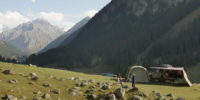
Only a few kilometres past the first checkpoint we came across another that was much larger and included substantial barracks; it’s difficult to say how many soldiers are posted in this isolated place. After passing through this checkpoint it was time to set up camp. We like to camp hidden from view, so in a suitable looking spot we departed the muddy dirt road and drove overland around the back of some hills. It was cold, so Sylwia and the kids stayed in the car while I set up camp… and as I did so it began to snow! It snowed sufficiently to quickly turn our surrounds totally white. The family don’t like to get out of the ‘warm’ car until the ‘warm’ tent is ready. Although tents are not usually warm places in these conditions, the four kW diesel-electric tent heater I put together especially for this trip has transformed our camping experience!
Cold comfort
However, I was to discover a previously not encountered issue. I was to learn how diesel waxing in the thin fuel line between the heater and one of the Pajero’s fuel tanks would cause a problem. Being outside in the snow at 1:30am trying to resolve the issue was far from ideal and initially I misdiagnosed a faulty fuel pump.
I’m well equipped with tools and spare parts on this expedition and so set about replacing the fuel pump in the freezing cold, only for it to make no difference. The rest of that night was cold! But before this five-day circuit was complete, I had overcome the issue by utilising the heater’s own exhaust gases to preheat incoming fuel.
The following morning the kids managed to build a snowman and have a snow fight, before the still strong September sun quickly melted the snow. We packed up camp and continued onwards for Kel Suu. Poor weather returned and our route became increasingly bleak. We found ourselves driving in something between snow and hail in freezing temperatures. I drove with care on the hillside dirt surfaces of uncertain traction. You wouldn’t want anything to go wrong with the vehicle out here, alone.
We’re extensively prepared and equipped, but there can be no guarantees that a high level of preparation will resolve all potential issues and I feel acutely reminded of this fact when in these remote locations and challenging conditions.
Eventually we arrived in a small settlement of yurt camps located as nearby to Kel Suu as most vehicles can get. I was surprised by how rapidly the bad weather cleared away to reveal clear blue skies, though it remained cold due to the 3,500 metres elevation. We found an awesome spot to set up camp above a river. Initially we set up just the Batwing awning and walls to provide a sheltered area out of the cold wind to cook a hot meal – it works great for this purpose. After lunch we decided it was too late in the day to commence the difficult section to Kel Suu and so I set up the tent too.
Getting closer
On day three we packed up camp and headed for the main attraction; Kel Suu! It was about a further seven km from where we were camped and in warmer conditions travellers to this area might hike or take an organised horse trek. A 14km round trip hike didn’t appeal given the very cold conditions, so we tackled it 4WD-style, though the going proved tougher than expected. Much of the track went over very wet and boggy terrain and I was pleased to have fitted a new set of MT tyres in Kazakhstan (this because one of the tyres we departed New Zealand with had suffered a surprise blowout!).
We’re no stranger to narrow cliff edge tracks and have ample experience of these from navigating Morocco’s high Atlas Mountains on previous expeditions. But I don’t like slippery off-camber cliff edge tracks, particularly where the slope is towards the cliff edge! We got into some difficulty with such a section on our approach to Kel Suu. I had already readjusted tyre pressures to better suit the soft terrain, which worked great until we reached a section with deep muddy ruts and a hole in the track.
We weren’t stuck as such and this would have seemed far more manageable down on the flats, but with the Pajero’s front left in the deep muddy hole I needed to put down some power for the tyres to claw up and out.
However, this was causing the rear end to want to slide around too near the cliff edge for comfort. And we recognised that our determinedness to reach Kel Suu was leading us to risk biting off a bit much for a solo 4WD, though equally it appeared we had reached a point of being committed to continuing forwards, as I’d not want to reverse through the difficult section.
Board rider
This had potential to lead to a dire situation were we not well equipped to deal with various off-road and recovery scenarios. Given the lack of a suitable anchor point ahead for the winch, the best option was to get the traction boards down from where they’re easily accessed on the side of the Pioneer Tray. I find the traction boards to be an excellent tool – they lodge quite firmly into whatever terrain is causing issue, while the tyres engage confidently with the topside.
They worked perfectly in this situation and I drove straight out of the mud hole that had been causing some serious grief. For the remainder of the difficult section we didn’t wait until the traction boards were essential, rather we simply laid them down over any obstacle along the cliff edge portion of the track that had potential to turn nasty, and it worked great.
Finally, the destination that justified the effort, Kel Suu, at 3,525 metres. (Aoraki/Mt Cook is 3,724m Ed). We regard this as one of the most stunning natural locations we’ve visited in Central Asia, or anywhere! I have a short video from our journey to Kel Suu that readers are welcome to view – it can be found at: www.5goverland.com/videos (you’ll find three short videos from Kyrgyzstan.)
Kel Suu back to Naryn
We did not return the way we came, instead progressing clockwise around the loop shown in the GPS track map. Our route back towards Naryn proved even more remote, taking us through increasingly isolated areas where we hardly saw another person.
At one point we passed a seemingly abandoned village falling into ruin and went in for a closer inspection. We no longer make the mistake of presuming such places are uninhabited, and this one too proved to still have a resident or two.
Occasionally the route took us through rivers in low flow, which is fortunate given that the only bridge serving the entire area appears to have been washed out long ago and not replaced. We spent our third night camped up on a plateau in the hills, again hidden from view.
A tea towel hanging in the Pajero’s back window was frozen ‘crispy’ even before dinner had finished cooking, strongly indicating that we would need the tent heater to run on a low setting all night, and thanks to the new preheated fuel intake, it did.
I don’t have the space here to describe the remainder of the five day loop in detail, but I guide you to the photo showing a lonely dirt road running alongside countless miles of very serious barbed wire fencing (sometimes triple rows of barbed wire fences!) and military watch towers. This because we were still inside the military controlled border zone with China. It did not appear that any watch towers were actually manned, other than by a ‘dummy’ soldier at one watch tower, which from a distance was convincing.
Caravanserie
I’ll also briefly mention another highlight from this route, being the 15th century caravanserai located in a place known as Tash Rabat. A caravanserai is roadside inn (essentially a very old and basic hotel) where travellers (typically travelling merchants) could rest and recover on their journey. This particular caravanserai is believed to have originally been built as a Nestorian monastery in the 10th century. Whatever its precise origins, it still stands in excellent condition and the kids had a fabulous time exploring its labyrinth of stone hallways and accommodation rooms.
My next installment in this series from Central Asia will be from Tajikistan, where we find that our exposure to altitudes above 3,000 metres in Kyrgyzstan has assisted in preparing us to continue our adventures above 4,000 metres elevation.


