I first joined the New Zealand Four Wheel Drive Association back in 1985 through the Manukau 4WD Club. The club was very active in those days – a group of similar aged folk and a great social circle. In 1988 a national NZFWDA Jamboree was organised by the Otago Land-Rover Owners Club based in Bannockburn near Cromwell. My brother and his wife joined the Manukau club (briefly) to enable participation and the Jamboree was attended by a vast number from all over the country. This was where my love of ‘Central’ was born and to this day I relish the opportunity to hit those old Gold trails.
The NZFWDA have a monthly newsletter sent to all members and back in January 2023 ‘Notice’ was served for the Annual General Meeting to be held in Methven – but the AGM included five days (yep 5!) of Off-Road trips for the week leading up to the AGM on the Sunday, hitting the major Braided rivers in the Methven area. I contacted the organiser John McDonald and asked if the event would be like the old Jamboree I attended, and if so, could I advertise it on Facebook – to which he replied ‘yeah – I suppose we should have called it a Jamboree, and yes – the more the merrier’.
Naturally having a bent for Land-Rover I hit all the New Zealand Land-Rover pages with the entry details, and I understand that all trips were fully booked out within weeks with a total of just over 50 vehicles. To reduce the load on the tracks, John split us into two groups – ‘Shiny / Newby’ and ‘Tough-Truck / Experienced’.
My calendar was a tad tight by this stage: the Land-Rover Series 1 trip in March, two weeks later leaving for Wanaka in the Defender for the LR75 at ‘Wheels at Wanaka’, and now the Methven run 3 weeks after returning from Wanaka! I decided to take my Discovery down for Methven as it was better equipped for the ‘Boulder-Bash’ with fully plumbed raised breathers for axles, gearboxes and engine – bash plates on the diff – real ‘Rock & Tree’ sliders and strengthened steering rods… and mate, was I glad I did!
Due to work and farm commitments my wife and I decided to just go straight there and back, so leaving Saturday morning – arriving in Methven Sunday night. I also decided to transport my ‘Mud-Tyres’ and drive down on road tyres to save the treads and stays safer on wet roads, and we could share the driving.
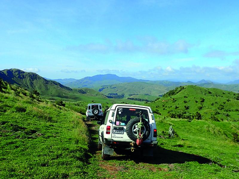
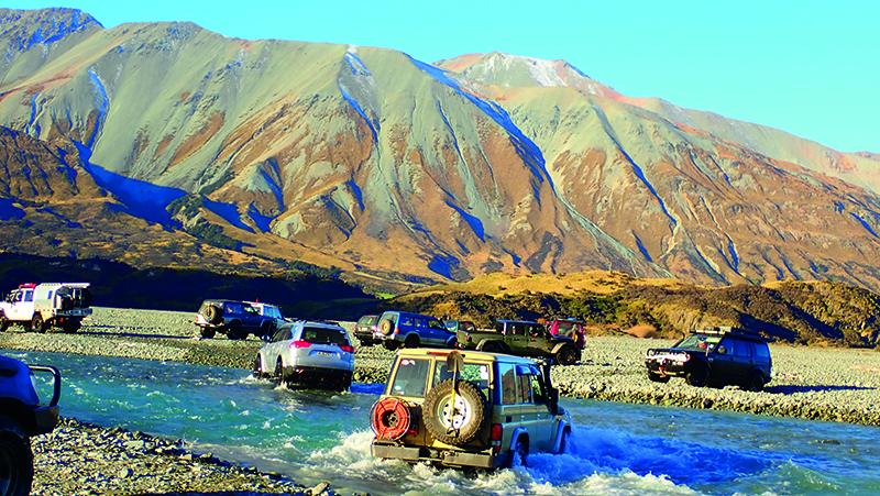
15-May-23. Monday morning was a tad brisk with a mild fog as we all gathered at the Methven Memorial Hall for the driver briefing. It was obvious there was something big on with steaming hairy-arsed 4WDs lining both sides of Main Street. After catching up with many acquaintances from all over the country, we all hit the road – with some ‘Shiny’s’ lining up behind the ‘Tough’ and visa-versa and wrong radio channels and different queues and Trip Leaders racing up and down the road as we parked outside the local College causing mayhem for the usually quiet town – BUT EVENTUALLY we hit the road south towards Geraldine and the Peel Forest to head up the true right of the Rangitata River. We aired down near Mesopotamia Station before making our way out across the ancient riverbed. By this stage the morning fog had cleared leaving an ice-blue sky with paint-stroke wisps of mist up the 2000m+ ranges across the valley like sip-lines up a beer glass.
One of the factors to attend the Jamboree was to gain confidence tackling Braided Rivers. We have some big rivers up north, but these southern units are on a different scale. I have inner tubes in my ‘Muddies’ which permits much lower tyre pressures without ‘popping’ the beads, so I turned this to my advantage by dropping them to 14psi in the rear and 18psi in the front providing a more comfortable ride with my usually heavy-duty suspension. Having the vehicle slightly raised and a bespoke bar on the front and a short recovery plate at the back provides a very good attack and recovery angle. All these factors played a critical part in the coming days for minimal rock contact to sensitive areas.
And here we go – we pulled up alongside a tributary of the Rangitata which appeared to be running at a good sprint – the surface smooth which usually means IT’S DEEP – and light blue meaning its glacial fed so you can’t see the goorie rocks either. I could see the wide eyes on the drivers… and passengers faces as they ploughed into the swift water – heading slightly down stream (READ swept down torrent) so the current pushes you to emerge steaming on the other side. Two of the Land-Rovers many design features include door seals designed to leak like a sieve to allow the vehicle to sink, as opposed to bob like a cork in deep crossings – with another being the floors are flat and bevelled towards the doors in all Land-Rovers to allow free draining, unlike lesser vehicles whose owners were using take-out food trays to bale out the aptly named ‘foot-wells’ or was that foot-bath.
At the next crossing I asked our trip leader if he could give us northerners the ‘101’ of braided river crossings – to which he just looked at me blankly. I guess it’s not that he didn’t want to share his knowledge, but to explain a task which is second nature to one, can be difficult to put into words for the benefit of others. Fording braided rivers makes up the bulk of these clubs four wheeling – where us northerners are more acquainted with thick mud driving.
I had never noticed it before, but at this point the Rangitata River stops, and the source becomes a combination of the Havelock and Clyde Rivers. We followed a clear track on a vegetation covered island up the middle of the Havelock for some distance before again fording the Havelock close in to the base of ‘Rocky Ridge’ to stop at ‘Growler’ Hut for lunch on the western side of the river. By this stage it was just before 1pm, so with a compulsory turn-round time of 2pm we only ventured to the next river braid before turning around – failing to make our target of Mistake Flat Hut, a tantalisingly short distance ahead.
We headed back east crossing the main flow of both the Havelock and the Clyde in the heavy shadow below Cloudy Peak Range to arrive at the southern tip of Erewhon Station, then to headed out via Hakatere-Potts Road which shaved a huge chunk off the return journey to Methven.
Distance covered: 239km Duration: 9:46.
16-May-23. Tuesday morning was freezing – promising a stunning clear day on the tracks. We retraced our steps back up the Hakatere-Potts Road to Erewhon where we again aired down and hit the deep Clyde River, heading due north following a track across a vegetation covered flat before again crossing the Clyde east to the original Erewhon Homestead – a tiny hut of about 20 sqm.
From the Erewhon Hut we entered the Lawrence River gorge and followed a good trail up the centre to arrive at the Hermitage Hut by just after midday for lunch in the sun. The Hermitage Hut is owned by Erewhon Station and with dog kennels and a horse pen next to the hut is an obvious musterers overnight stop.
Following lunch, we made our way back down the Lawrence stopping at Lawrence Hut before we were overtaken by the afternoon shadow of Mt. Jollie and McRae, when the temperature just plummeted with the eastern side of the river still bathed in sun. We were in frost conditions by the time we reached the old Erewhon Hut. From here we precisely retraced our steps back to Methven arriving just before 5pm.
Distance covered: 205km Duration: 9:00.
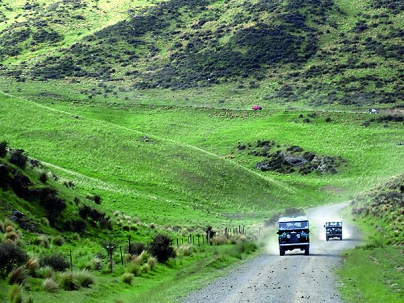
17-May-23. Wednesday and our gentle clear days were over with the return of some cloud cover and a not so favourable weather forecast for the other side of the ranges. Today we headed north out of Methven to suddenly turn up Blackford / Double Hill Run Road until it eventually fell into the Rakaia River by Walker Island. Here we aired down and followed the power lines supplying Manuka Point Station across the Rakaia. On the far side we hung a left and followed the true left of the Rakaia through some epic bogs which for the most, held a good base being sediment over the riverbed.
It was about Totara Point where we kinda lost the plot (so to speak), and commenced a serious patch of vehicle damaging boulder bashing up the left of the river to cross at a less than ideal location higher than we should have. At this point the river was running very swiftly and deep and I captured some stunning video of vehicles semi-floating across the teal-blue river – some suffering serious damage to their more sensitive bits under their vehicles.
A check on Satellite view of Google maps later that day over a cold beer back at the Pub clearly showed our return track (!) through the Matagouri vegetation opposite Totara Point, which we followed on our homeward trip having stumbled upon Washbourne Hut for lunch just after midday, forgoing our target destination of Reischeck Hut several kilometres further up the valley.
It is interesting to note that we were only a few kilometres north from our sunny lunch spot yesterday at Hermitage Hut directly over the 2628m North Col towering above us. Nothing much to report for our return journey…. following the track to calmer waters and back through the swamps to retrace our path down the formed roads on the right of the Rakaia River to Methven.
Distance covered: 162km Duration: 8:30.
18-May-23. Thursday we headed north again but to the northern side of the Rakaia and Harper Road to the Harper Campsite to air down. Today we are to follow parts of the national walkway – Te Araroa Trail up the Harper River, a major feeder to the electricity power storage lake, Lake Coleridge to reach Hamilton Hut on the western side of the Craigieburn Range over from the Mt. Cheeseman Ski Field. The day did not look great as we headed up the misty valley in the rain following a man-made boulder bank which is constantly maintained by a D10 Bulldozer to protect the Lake Coleridge intake flow.
The track today was very clearly defined partly due to the restricted width of the Harper valley, unlike the kilometre wide valleys of the previous days. We crossed and recrossed the river entering rain-soaked dripping Alpine Beech Forest across ancient bends – some with challenging swamp sections and before long, reached the end of the road, about a 20 minute walk across an ancient forested slip from Hamilton Hut.
By this stage the heavens had really opened up and some folks gathered under the few pull-out shelters on well equipped vehicles – or sat in steamed up vehicles with hot cups of tea and coffee for a well-deserved break.
Our return journey took us up a short diversion up the base of the Grey Range behind the Pinnacles where we encountered a section of clay where us Northerners felt at home, while our southern brethren were out of their comfort zone. We popped out the lower Avoca and had a quick look at the Wilberforce water dyke which also feeds Lake Coleridge – as the temperature plummeted and by just after 4pm it was quite dark.
Distance covered: 189km Duration: 9:30.
19-May-23. Friday was a multi-choice day where we had the chance of bashing our way up the Wilberforce to Urquharts Hut just over the ridge from Hokitika – or a more relaxed trip up to the Avoca to Basins Hut… we chose Basins Hut. As it turned out, the flow rate of the Wilberforce was such that the organisers deemed it too dangerous to attempt the Urquharts, so they combined the two groups into a mighty convoy to retrace most of our journey from yesterday.
It was a chilled (!) day up the Avoca – with lunch next to Basins Hut and we were back in Methven before 4pm, so I had time to swap my tyres back to road-mode before dark (and rain) set in.
Distance covered: 107km Duration: 5:00.
20-May-23. Saturday was ‘Business Day’ when the remaining delegates were to arrive and ‘activities’ were arranged which included group discussions on various topics including ‘Land-Access’ and ‘Driver Training’ in the morning and visits to a 4WD Park and various Museums in the area. My wife and I did the Jet Boat ride, which was a bit of a fizzer – I assume due to the promised number of 18 dwindling to 6 meant more sit in the boat and chat than distance covered, but thems the breaks.
21-May-23. Sunday was the AGM – and due to Mr. COVID paying several delegates a visit the previous day, I was roped in to represent the LROCA.
The meeting was wrapped up by 2pm, so we pressed on to Kaikoura for the night and were home in Auckland by Tuesday afternoon.
I would really like to sincerely thank the organisers Mid-Canterbury Four Wheel Drive Club Inc., particularly John McDonald, for organising the outstanding trips for us all.