As they traversed the Pamir mountain range through Tajikistan Kiwi Overlander Aaron Rich and his family spent several days at dizzyingly high (+3000m) altitudes –but lived to tell the tale!
The Pamir Mountains include peaks around 7,500 metres, with the road we drove going as high as 4,655 metres (nearly one kilometre higher than the peak of Mt Cook!). This 2,000 year-old route taught us valuable new lessons as overland travellers... including one learned the hard way!
Most overland travellers would pick just one route through the Pamirs, however I was eager to explore this fascinating region more thoroughly than that. Most go via the not to be missed Wakhan Valley, while others remain on the Pamir Highway, but it seems few even know a middle route exists – we explored them all, as well as two stunning side valleys.
Setting off from Kyrgyzstan’s interesting little city of Osh (963 metres), we gradually ascended from the lovely warm climate prevailing there, to a far more bitter one in Sary-Tash (3,178 metres).
As I look back through the images we’ve collected from Kyrgyzstan – and now Tajikistan too – I note a number of them look as if they come from different seasons through the year, whereas in fact it’s all just down to the drastic changes in elevation possible in these countries.
Even just within Tajikistan’s Pamirs life is very different at between 2,000 and 3,000 metres elevation vs 3,000 to 4,000 plus metres.
Believe it or not we were perfectly cosy on our first night along this route, camped just outside Sary-Tash in the snow. But only because my diesel-electric tent heater worked through the night and didn’t first fail until the morning, just as we were about to pack up (see the sidebar article for an explanation as to why the heater kept failing in the Pamirs).
Feeling anxious about heading above 4,000 metres into the snowy mountains without a working tent heater, I changed priorities and set about repairing and testing it in a bitterly cold wind, while Sylwia cooked lunch, and the kids wisely stayed in the Pajero. With the heater fixed, though me not yet aware that the high altitude would only see it fail again in short order, we finally began our ascent out of Sary-Tash late in the afternoon – not ideal and we briefly considered delaying the border crossing to the next day, but carried on.
The friendly Kyrgyz border guards seemed in high spirits as we exited Kyrgyzstan and were eager to know what I thought of their country; it seemed important to them that I considered it better than Kazakhstan. It’s odd how it eventually becomes fairly normal to be making conversation with heavily armed soldiers at these remote military controlled border checkpoints.
Once through the Kyrgyzstan checkpoint we were immediately out into the ‘no-man’s land’ that exists between Kyrgyzstan and Tajikistan. To reach the Tajikistan border checkpoint, situated at a lofty 4,282 metres, we needed to ascend a lonely, slippery, mud and snow road.
Welcome to Tajikistan!
With light falling we reached the remote border checkpoint controlled by Tajikistan’s military, situated all alone on a snowy mountain pass at 4,282 metres. The only large building initially visible through the barbed wire was derelict with broken windows, though after a short while soldiers emerged from a tiny station to open the gate and usher us in. Processing took place at three rough and ready stations within the compound, continuing until after dark. The third and final station was fake – my thorough research prior to undertaking this route had made me aware that this border checkpoint had earned its reputation as the most corrupt in all of Central Asia. But merely knowing this didn’t prepare me for how to handle a confrontation with border guards eager to extort money for fake taxes – in my case a ‘vehicle disinfection fee’. The solution turned out to be much simpler than expected, but only because we were fortunate to find the exit from the compound unguarded.
When presented with an invoice that I knew to be fake, and after attempting to convey that I knew I didn’t need to pay this particular tax, I changed tactic and indicated I would need to go out to the car. The family were already in the car and I’m sure the guards presumed I was going out there to get money, but instead I jumped in, turned the key and we departed. This would sound considerably more ‘James Bond’ like if I permitted you to form the impression we sped away, wheels spinning in the snow...!
However, given the effects of high altitude (see the sidebar article) on the Pajero’s engine performance, it would be more accurate to say that we slowly chugged away in a puff of black smoke.
Damn, why do I have to be so honest about it? I should have left it at the ‘James Bond’ style impression, maybe even have dressed it up further and claimed to have run to my car and slid across the bonnet to shave off the precious two seconds it would have taken to walk around to my door. You might have seen through that one – the bonnet is quite high.
Regardless, the key point is that we ignored the border guards yelling and whistling as we escaped ‘extortion-free’ into a dark and snowy night.
Camp at Lake Karakul
And so, another border within Central Asia successfully navigated! On a more serious note, however I only got away with this due to the generally sloppy and corrupt manner in which this border checkpoint is run.
At most of the borders we’ve crossed on our 5GoOverland journey I would never have dared to dare defy strict instructions given by no-nonsense soldiers toting serious automatic weapons.
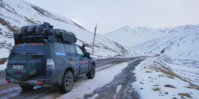
We drove out of the snow while descending to 3,900 metres and made camp on the shores of Lake Karakul. It was minus five degrees Celsius as I set up the tent, and though it was apparent the tent fabric was frozen and ‘crispy’, it didn’t feel too bitter in the perfectly still air. But mostly I was braving the cold, safe in the knowledge that as soon as the tent was up the heater would be switched on. It was, and it allowed us a warm dinner in the tent before failing again not long after we’d gone to bed.
We quickly put on all our jackets and returned to our sleeping bags. Though it was obviously very cold the next morning, we were pleasantly surprised by just how strong the October sun still was up there and the day warmed up reasonably quickly.
After packing up camp the first settlement we passed through in Tajikistan was the tiny village of Karakul; described by Lonely Planet as looking as if it has weathered one too many storms. The remainder of this day’s drive took in some stunning high-altitude scenery and included driving the highest pass in the Pamirs – the Ak Baital (4,655m) - which I had not expected to find virtually snow-free as late as October.
Arriving into Murghab
There’s only one seemingly quirky hotel in the settlement of Murghab (3,618m) and we quite liked the idea of staying there for an experience, but were to discover it had closed for the season at the end of September. We decided to try a nearby homestay and it turned out to be a great experience. Our accommodation was heated in the traditional way up here, being a dried cattle dung fired stove. Water for our shower was warmed up via the same means, and I’ve no doubt whatsoever that dinner was cooked on it too!
I can assure you, though, that no unpleasant odours were detected. With few fuel alternatives in this desolate place, cattle dung is a staple fuel source and I must admit to being impressed by its effectiveness.
One wonders how local people eke out a living in Murghab. The winters must be particularly harsh. Even if at first glance it appears the environment surrounding Murghab gives local people little to work with. During our time in Tajikistan we would have ample opportunity to experience first-hand just how incredibly self-sufficient Tajik people are.
I found myself pondering whether a Hollywood-style ‘world apocalypse scenario’ would have any effect on the people living here at all, because in many respects it seems like they’ve already adapted to surviving with so little resource.
To the mall!
Murghab has a shipping container shopping mall. It’s nothing flashy, but you can find most of what you might be looking for there. Several container stores sell groceries and I saw a butcher. Other container stores sell clothes, hardware or car parts etc.
I decided to buy some diesel in Murghab. Given the absence of any real fuel stations’ this was ‘black market’ diesel sold out of containers.
I must stress this was not for the Pajero. I wouldn’t dare put fuel of unknown quality near its engine if I could help it. Our tent heater is less picky over fuel quality – to the extent I could keep it operational at this altitude!
Speaking of fuel, the Australian-made auxiliary fuel tank by Long Range Automotive really proved its worth in the Pamirs, giving us 170 litres of on-board fuel capacity and hence the range needed to drive all our Pamir routes.
Madiyan Valley
There’s more to the area surrounding Murghab than initially seems apparent and a side trip up the nearby Madiyan Valley proved a great way to deepen our experience of this unique area.
A major attraction for me in heading up the Madiyan Valley was to bathe in a natural hot spring that I knew existed somewhere up there, even if described by Lonely Planet as ‘barely accessible’ by 4WD. The drive up the main part of the valley was stunning, set against incredible rock-walled mountains and following pastures alongside the beautiful clear river. I can imagine that earlier in the season this area would be greener and more fertile relative to the terrain directly surrounding Murghab.
The rugged part of the 4WD access began across the river from the micro-sized village of Ak-Tal and involved some cliff edge driving on narrow rocky tracks, though nothing out of the ordinary for us. Seemingly defying its fully laden touring weight, the Pajero navigates such tracks like an agile mountain goat.
We located the old hot pool beside the river where a hot spring naturally bubbles up. The pool, which is enclosed in a rustic old stone building, has long existed in this isolated location and is freely accessible to locals and visitors alike.
Our Coldest Night!
The next night would prove to be our coldest, with the readout on the Pajero’s dash showing minus 11 degrees Celsius early the following morning. The heater kept us cosy into the evening, before failing around bedtime, but of course I wasn’t at all surprised anymore and all our warm clothes were within arm’s reach ready to put on.
Fortunately, again, the morning sun proved powerful and the cold morning warmed quickly to a pleasant day. We ventured through the small settlements of Alichur and Bulunkul before pausing for brunch on a cliff above nearby Lake Yashikul at around 4,000 metres. Bulunkul is known as one of the coldest inhabited places in Central Asia, though it was pleasant enough on the sunny October day we paused there to refill the Pajero’s water tank at the village well – giving locals reason to gather and observe, as often occurs.
We were determined that our next night’s wild camp would be situated below 3,000 metres so that we could go back to relying on the heater again... which I might add was stripped, cleaned and rebuilt for the third time on that cliff above Lake Yashikul in eager anticipation! Incidentally, that cliff, which is about as far into the middle of nowhere as you can get, is as far as we would have gotten without the second fuel tank.
Coming up in Part 2 of this Article
We leave the Pamir Highway behind and travel via the isolated Khargush Pass to the incredible Wakhan Valley, separated by a narrow strip of a river from Afghanistan – we could see the Afghan villages on the other side! We are shown wonderful hospitality by a local Tajik family and have opportunity to experience first-hand how they live. We bathe at the ancient Bibi Fatima springs and explore the site of a large 12th Century fortress in the mountains before moving on to Khorog; a small town regarded as the capital of the Pamirs. We then loop back into the high Pamirs via what I refer to as the ‘middle route’. Images that I will share in Part 2 will reveal that the Western Pamirs have an entirely different appearance and climate at lower altitudes, between 2,000 and 3,000 metres.