Getting out into the quiet back roads of this country is often an inspiring, rewarding experience. Here’s the first instalment of a laid-back, scenic tour of an area with a lot to offer…
After the usual busy Christmas period – with plenty of club 4WD trips, of course – I decided to use the last few days of my holidays to do a trip up to the Taranaki region to explore some back roads. The motivation for this was a couple of books on North Island back roads and 4WD tracks written by Andy Cockroft, which I had picked up about ten years ago and used to explore the greater Wellington area. I had also tried some of the tracks further afield when I was able to fit them into my other travel plans, but there are still plenty of tracks I haven’t done yet – especially in areas like Taranaki that I rarely visit.
After a bit of research in the books and cross referencing with my NZTopo map-based software, I had a route planned out that would combine some touristy visits with some good back road tracks. The plan was for me and my wife May to travel up to New Plymouth with a few scenic detours one afternoon and stay the night. This would give us an early start on the main day of exploring, with the option of either spending a second night in the area or doing a longish drive home that evening.
We left Wellington on a beautiful, mild summer’s day and had a very easy trip up, pausing for a late lunch at lovely Victoria Lake in Wanganui. Reaching Hawera we decided to take the Surf Highway (Highway 45). This upset the Google Maps GPS software on my iPhone a little as it kept telling me to turn right down every side road we crossed to get back onto SH3. Finally it ran out of side roads and recalculated for using the Surf Highway. This gave us some peace until we decided to detour to the coast at Opunake. I had to turn the sound off to get some relief from the instructions to do a U-turn.
We dropped into the Opunake camping ground and surf beach for a break and had a very pleasant interlude enjoying an ice cream in the sun before returning to the main road. The remainder of the run to New Plymouth was uneventful and the GPS redeemed itself by getting us to the motel perfectly. After we had settled in I went and fuelled up for the next day and was very pleased to find I was getting 10.5 L/100km from my 3-litre diesel Prado – a theoretical range of over 800km. We also had a very pleasant walk along the coastal promenade and browsed the outdoor exhibition of sculptures. Although these were for sale, luckily for me the ones we liked were all too big to fit in the vehicle.
The next day we enjoyed breakfast on the balcony of our motel unit before heading north about 90km to our first back road, which was just past the south Waikato town of Awakino. On the way up we detoured to follow a sign to the well-known Three Sisters rock formations. This took us through a small bach community to a beach on the mouth of the Tongaporutu River. The limited signage here indicated it was a walk along the river bank and coastline to the Three Sisters, but that it could only be done at low tide. As the water was already hard up against the coastal cliffs, we decided to leave this for another time but enjoyed a few minutes for morning tea, soaking up the fresh air, peace and scenery while watching a fisherman landing a stingray.
Continuing on, we soon reached Awakino where we ran out of cell phone coverage for the Google maps GPS software I had been using so far on this trip. Time to switch to the Galileo GPS software, also in the iPhone. This uses a range of maps, including the NZTopo maps, which are much more useful for back road touring. One of the most useful features of Galileo is that I can use similar mapping software on my computer to set way points (although not on actual tracks) then download these to the iPhone for use by Galileo. I can also create files of selected areas of the detailed topographical maps to load to Galileo for use when I am out of cell phone range. For this trip I had set up way points to follow the tracks I was interested in and was using the GPS to navigate from way point to way point. I found this very effective, especially when I set the way points just past an intersection on the road I needed to turn onto.
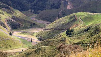
Our first route was Taumatamaire Rd, which runs parallel to SH3 along the ridge line on the seaward side of the Awakino Gorge. Being gravel and a little corrugated, this 20km run was a nice, gentle introduction to the day’s back road touring, offering some very nice views from the ridge line. There was a lot of suicidal free-roaming sheep on this section and, although I fortunately didn’t need it, I was wondering if my bull bar would need to be re-christened a ‘sheep-bar’. Toward the end of Taumatamaire Rd we passed a number of rock outcrops that looked like miniature versions of the Pancake Rocks at Punakaiki.
Rejoining SH3, we returned through the Awakino Gorge and headed south towards Uruti and our turn off to the next set of back roads. Lunch was at a roadside rest area en route, not my favourite type of place to stop, but the view over the Tongaporutu River mouth where we had stopped for morning tea was worth the noise of the occasional vehicle going past.
At Uruti we turned up Uruti Rd then a few kilometres further on we turned into Moki Rd, the start of the next part of our trip.
Continues next month.


