With a rather hectic round of work and family activities behind us, May and I decided to take advantage of a long weekend to get away and catch up on the back road sections of the northern Wairarapa we missed on our last trip. The plan was to get to Masterton then follow as many back roads as necessary to take, as near as possible, a straight line to Waihi Falls on the Waihi stream. This was to be our lunch stop, after which we would get back onto SH52 and run up to Wimbledon, where we would turn off to visit the beach at Herbertville. Returning to Wimbledon we would return down SH52 a little way before cutting cross country again to the Akitio road, where we would loop down to Akitio for what would probably be a late afternoon tea before continuing round the loop back to SH52 then on to SH2 at Eketahuna.
Just out of Masterton we turned off the Castlepoint road onto SH52, a reasonably good sealed road, although a number of subsidences and some rough repairs meant it paid to keep the speed down. On the way to Alfredton I stopped a few times to take photos and, as usual on these trips, enjoyed soaking up the peace and tranquillity of the area as much as looking for the right photographic angle. By the time we finally reached Alfredton it was getting later than I had hoped so we changed plans and used the pleasant Alfredton Domain as our lunch stop.
We enjoyed a very peaceful although slightly breezy lunch before returning to SH52 and continuing for about 10 minutes before turning off into the well maintained Pori Road. This is so well gravelled it was actually quite slippery, and I found I was more comfortable in 4WD just for stability.
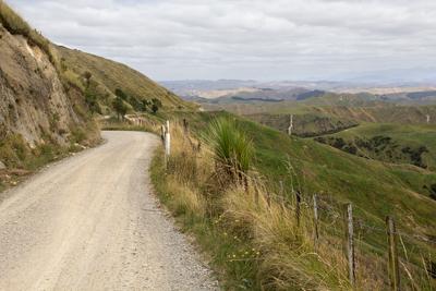
Pori Road soon started to climb, offering great views across the Wairarapa hills and valleys. Before too long we were running up near the ridge line with very steep, long drop-offs on the left and evidence of a few recent slips coming down from the banks above us to the right. The simple wire fences didn’t seem much of a barrier and I was taking it very carefully. I was very relieved we didn’t meet any oncoming traffic on this section.
As we reached the summit at the southern end of the Puketoi Range I spotted a bright red mailbox standing in splendid isolation on the side of the road with no driveway in sight. That triggered a vague memory, and as we continued through a few clusters of houses along the summit I started to feel that I had been here before. As we dropped down and came to an intersection I finally remembered that we had been along Pori Road before, although it had been buried in cloud that time and we had not really seen anything except the road and a hint of a drop off.
On that last trip, for my August 2012 article, we had turned right at the intersection and returned to SH52, but this time we were turning left and continuing down Pori Road heading deeper into the valley on the far side of Puketoi Range.
To my surprise the road soon became sealed, with native bush on the hillsides. This was a very attractive final section of Pori Road, taking us to the intersection of the much more substantial Pahiatua-Pongaroa road, which even had a white line down the middle. So much for heading deeper into the back country!
We followed the Pahiatua-Pongaroa road along the valley for quite a while, passing through the very attractive little settlement of Makuri before starting to climb into more open country and back over the Puketoi Range. We came across the remains of quite a few slips as we climbed, and just before we reached the top of the range we encountered the first oncoming vehicle we had seen since leaving SH52 for Pori Road.
At the top we stopped in a clearing for a short break before dropping back down towards SH52. We finally turned off the Pahiatua-Pongaroa road onto Waihi Valley Road, another unsealed road, and our destination was figuratively in sight, much to May’s relief. It had been a long drive and the plan to make this a lunch stop was well off time.
From the car park it was a very pleasant and relatively short walk down a couple of flights of steps to the Waihi Falls, and it was a good chance to stretch the legs.
To my surprise the falls were more of a trickle this time. We spent a very pleasant half hour exploring, photographing and enjoying the peace before climbing back up to the car. Stopping on the way up the path I couldn’t even see any water in the stream. As I got higher I realised that the water was flowing in deep channels in the stream bed and that there wasn’t even enough water to fill the channels, making the river look empty. A far cry from my last visit.
Our next destination was the beach at Herbertville. It was a short run back the way we had come to Horoeka Road, then another short run to rejoin the seal at SH52. From Horoeka Rd there were some great views of the coastal hills. It was a scenic but easy run up SH52 to Wimbledon where we turned off for Herbertville and the beach. Initially sealed, this turned into a good quality and well gravelled road as we approached the coast.
Herbertville itself is a reasonable sized community set back from the beach. The road slowly met the beach before climbing back up past a No Exit sign toward what looked like a station entrance. We stopped on the way back to get some fresh air and enjoyed a short walk along the wide, flat and interesting beach.
Returning through Herbertville I decided a trip up the beach to Cape Turnagain, while possible, was a bit risky for a solo vehicle, especially later in the day and without being sure of the tides. We followed our tracks back to SH52 then to Ti Tree Point where we turned off to cut cross country to our final beach at Akitio.
This was another good unsealed road, although after seeing a few logging signs I was a little concerned that this section would be closed. However, we got through the logging area without any problems and were again greeted with nice views across the hills as we climbed.
After about an hour, with the last section being a sealed road, we reached Akitio. This is another beach community, although a little more substantial-looking than Herbertville and with some larger, commercial fishing boats sitting on trailers. We drove down onto the beach to explore the rocks and enjoy a couple of freshly made avocado sandwiches, a plunger coffee and the amazing view. It certainly beats a Wellington cafe.
After one final scenic photo stop at the top of the hill leaving Akitio it was time to make the uneventful three-hour trek home. Winding back along SH52 and also on SH2 going over the Rimutakas was a great opportunity to check out my light bar in the back road environment I really got it for. I found it very effective, giving me a powerful spread of light coming into the corners on windy roads. It was less effective on the longer straight sections of SH2, since the actual range was not much more than the full beam lights; I could see far enough to react to any corners or other hazards on the road.
Overall it was a great touring trip and a very full day providing lots of memories and photographs.
By David Coxon


